Smith Lagoon Bay, NE
Smith Lagoon is commonly identified as a Rainwater Basin, but presented here as a western sibling of the east coast Carolina bays. C. W. Zanner and M. Kuzila had researched these basins and found them to be underlain by crisply defined oval rims, and made a comparison to the Carolina bay landforms:
"Our hypothesis is that the Basins on the current land surface originally formed as blowouts or low spots in abandoned Platte River fluvial sands and gravels. The ~27000 radiocarbon years and later loess actually draped a pre-existing topography formed in these sands. We also offer that these features would be recognized as an analog of the Carolina Bays if not for their loess cover. This suggests that Carolina Bays are not unique features, and any explanation for their existence should also help explain Nebraska's Rainwater Basins." Abstract at GSA
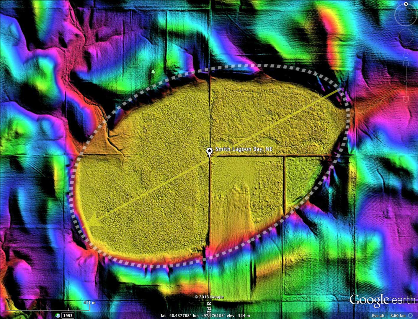
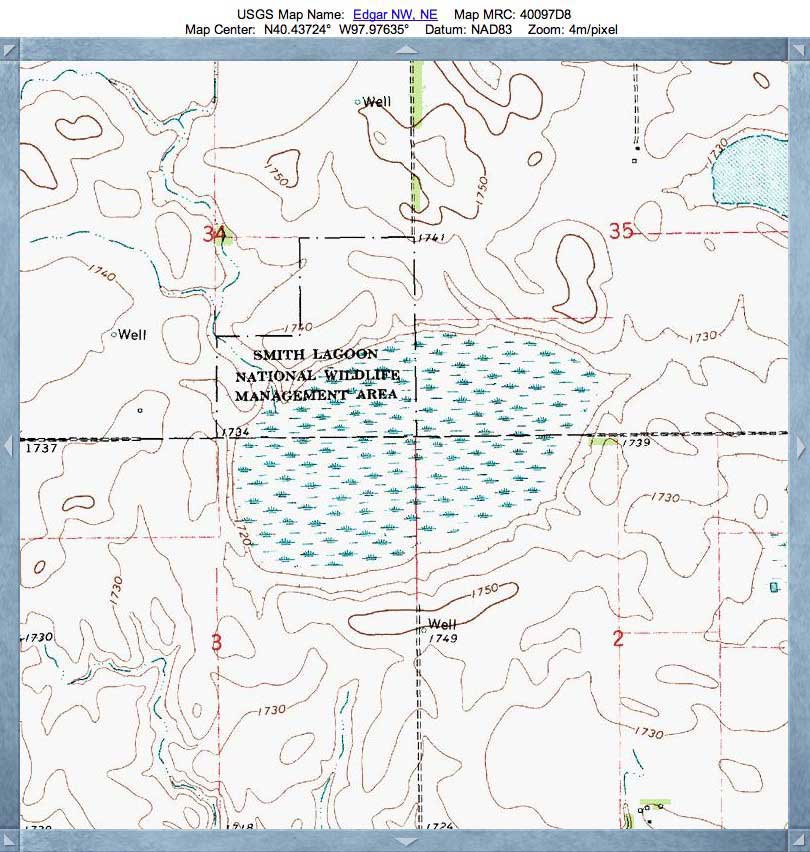
The basin presents as a well-formed bayWest archetype shape, and its orientation is consistent with the systematic by latitude & longitude seen in the Carolina Bay Survey.
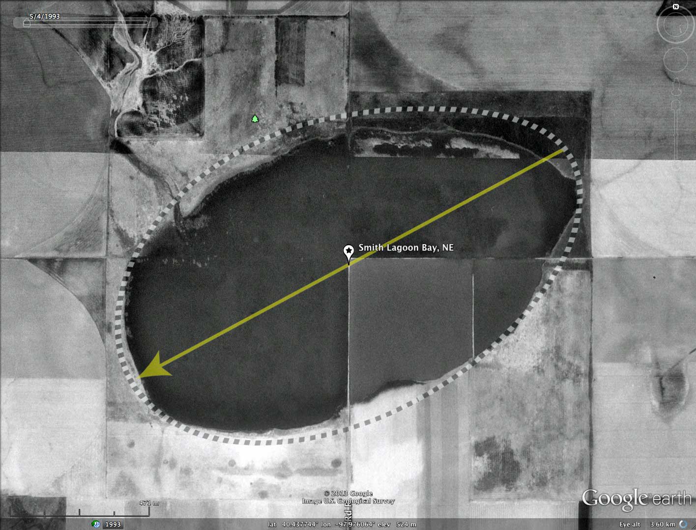
Historical imagery from 1993 (see album) suggests the basin had extensive rim-to rim standing water present. The LiDAR suggests there are drainage channels entering the basin on the western and western ends, providing plentiful recharge conduits. A small delta has formed on the north-west floor at the site of a drainage channel which enters the basin from higher elevations. No outbound drainage is present.
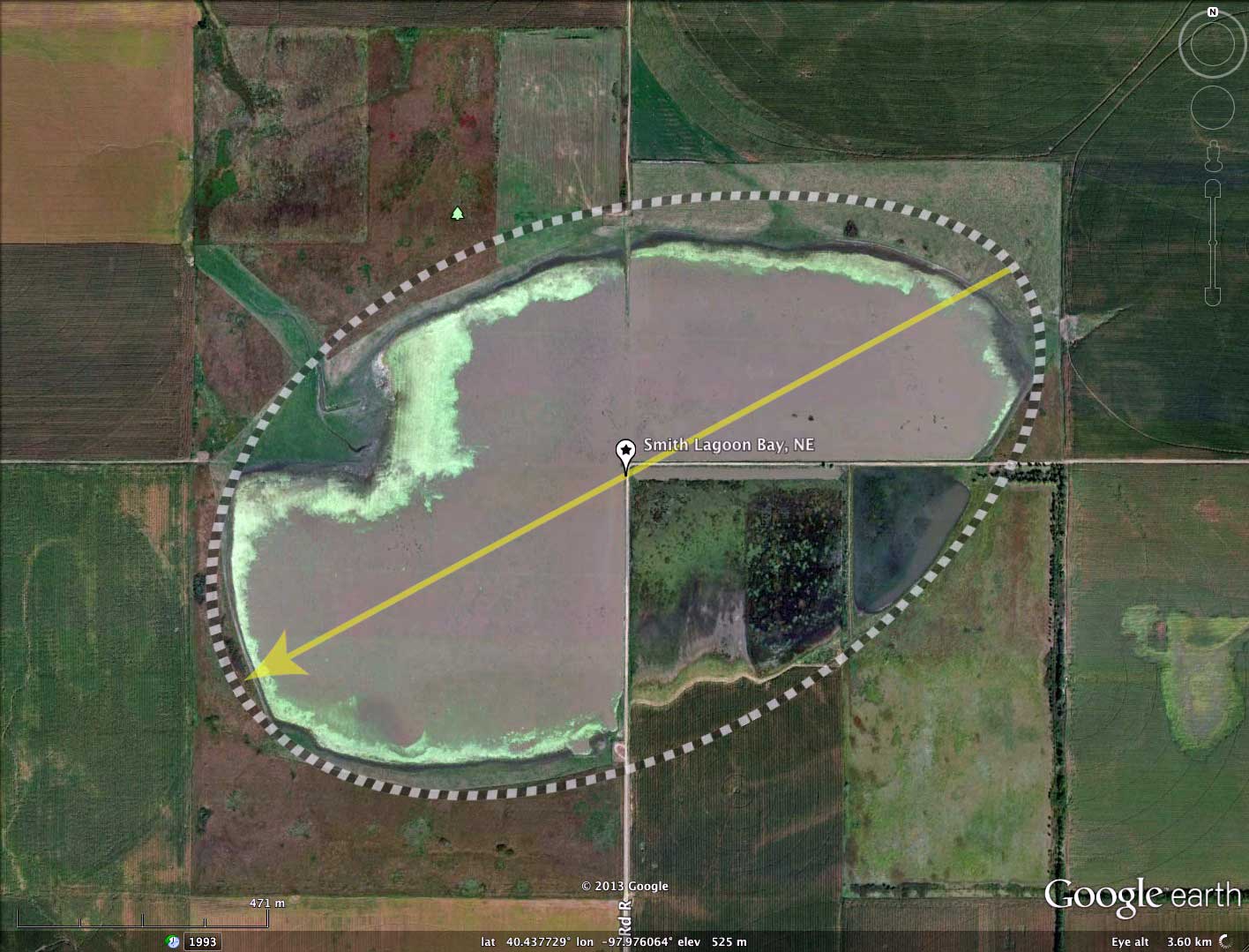
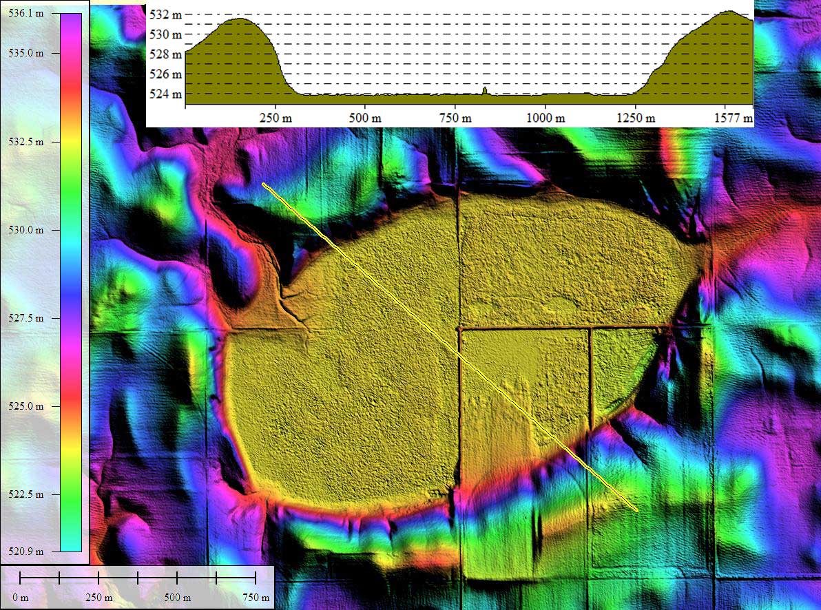
Within the bay, the raised roadways of Road R and Road 307 effectively box off the southeast quadrant of the basin floor, and has enable recent attempts at farming within the lagoon. To support that activity in the otherwise-wet surface, a 250 x 250 meter wide swath of the southern rim was leveled, and the material spread northward into the bay on the east side of Road R. Such an extensive movement of material has not been noted by me across the 40,000 bays in my survey. An elevation profile map is presented in the attached album, and shows this area in detail. The deep cuts across the rim may present an exposure for dating the rim sediments at depth.
Smith Lagoon is the site of a Nebraska Waterfowl Production Area, described by Nebraska Birding Trails:
"Located in Clay County, 6 miles south and 3.5 miles east of Clay Center. Habitat includes 226 acres of wetland and 254 acres of upland. In 1998, a new boat ramp was built in the southwest corner of the property. The west half was burned in the spring of 1999. Disking and grazing were done to open small pockets of water for pintail and mallard use. The small open-water pockets are not attractive to snow geese which use the larger, more open wetlands. During the spring of 2000 migration, the wetland was heavily used by pintail and mallard. Snow geese begin using the wetland towards the end of their migration. One of the reasons for their using the wetland may have been hunting pressure on larger open wetlands. The dry conditions of 2002 and 2003 allowed for disking most of the bulrush in the wetland. An excellent waterfowl area during spring migration."
"Our hypothesis is that the Basins on the current land surface originally formed as blowouts or low spots in abandoned Platte River fluvial sands and gravels. The ~27000 radiocarbon years and later loess actually draped a pre-existing topography formed in these sands. We also offer that these features would be recognized as an analog of the Carolina Bays if not for their loess cover. This suggests that Carolina Bays are not unique features, and any explanation for their existence should also help explain Nebraska's Rainwater Basins." Abstract at GSA
The basin presents as a well-formed bayWest archetype shape, and its orientation is consistent with the systematic by latitude & longitude seen in the Carolina Bay Survey.
Historical imagery from 1993 (see album) suggests the basin had extensive rim-to rim standing water present. The LiDAR suggests there are drainage channels entering the basin on the western and western ends, providing plentiful recharge conduits. A small delta has formed on the north-west floor at the site of a drainage channel which enters the basin from higher elevations. No outbound drainage is present.
Within the bay, the raised roadways of Road R and Road 307 effectively box off the southeast quadrant of the basin floor, and has enable recent attempts at farming within the lagoon. To support that activity in the otherwise-wet surface, a 250 x 250 meter wide swath of the southern rim was leveled, and the material spread northward into the bay on the east side of Road R. Such an extensive movement of material has not been noted by me across the 40,000 bays in my survey. An elevation profile map is presented in the attached album, and shows this area in detail. The deep cuts across the rim may present an exposure for dating the rim sediments at depth.
Smith Lagoon is the site of a Nebraska Waterfowl Production Area, described by Nebraska Birding Trails:
"Located in Clay County, 6 miles south and 3.5 miles east of Clay Center. Habitat includes 226 acres of wetland and 254 acres of upland. In 1998, a new boat ramp was built in the southwest corner of the property. The west half was burned in the spring of 1999. Disking and grazing were done to open small pockets of water for pintail and mallard use. The small open-water pockets are not attractive to snow geese which use the larger, more open wetlands. During the spring of 2000 migration, the wetland was heavily used by pintail and mallard. Snow geese begin using the wetland towards the end of their migration. One of the reasons for their using the wetland may have been hunting pressure on larger open wetlands. The dry conditions of 2002 and 2003 allowed for disking most of the bulrush in the wetland. An excellent waterfowl area during spring migration."
- Index #: 161391_7490
- Location: 40.43733733694225,-97.97605473854446
- Major: 1.66 km . . . Minor: 1.02 km
- Eccentricity: 0.787
- Area: 133.39 hectares
- Bearing: 241.77º
- Elevation: 524.07 m
- Archetype: bayWest
- Effective Diameter: 1,303.215 m

Copyright 2018 by Michael Davias