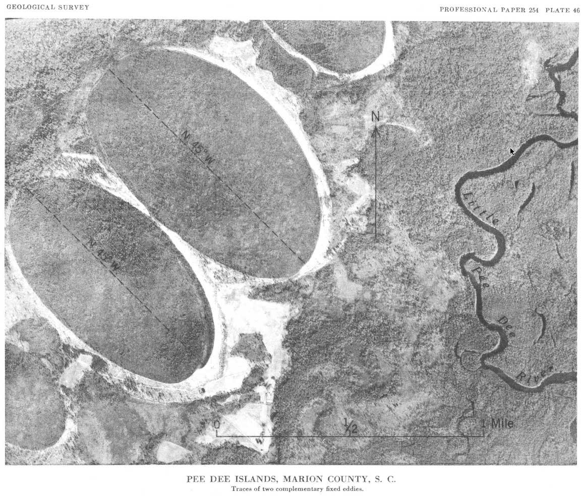
Pee Dee Islands, SC
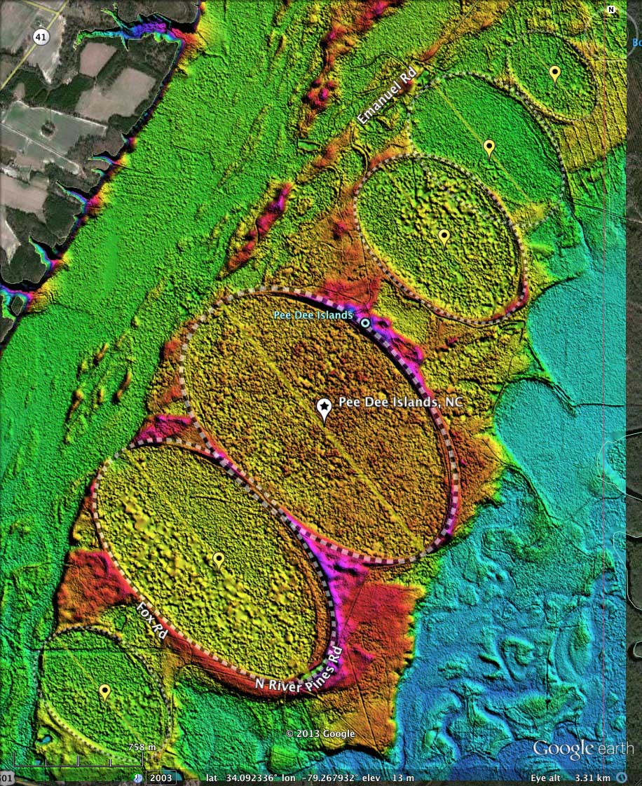
Presented here are six individual bay landforms which have been associated under the historical name "Pee Dee Islands". The largest, with a major axis of almost 2 kilometers, is our survey index # 136317_3607. they are listed here by decreasing major axis length. These six bays have the same orientation of 140.69, and are robustly represented by the standard bayCarolina archetype shape.
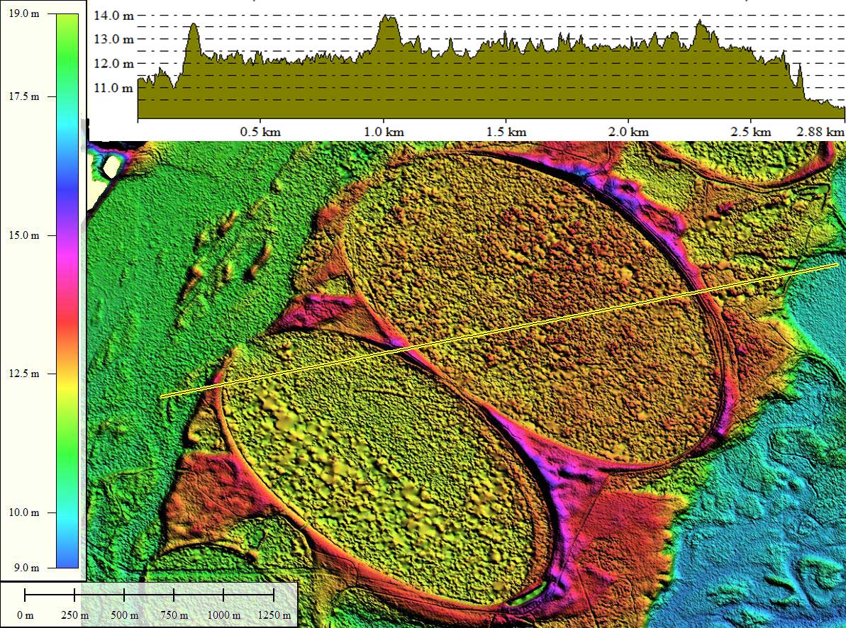
Perhaps the name "Islands" was applied because each of these landforms presented a encapsulated habitat in the middle of the Pee Dee River floodplain, and are all situated on a contiguous strip of land which rises above the older flood plain to the west (at 11 meters AMSL) and the more recent floodplain to the east (at 10 meters AMSL).
Each of these bays is exquisitely crafted, and certainly worthy of their own "day"; but their years of being associated is worthy of acknowledgement.
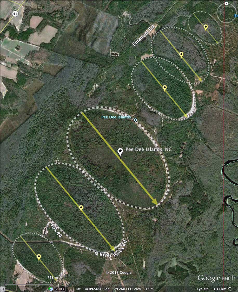
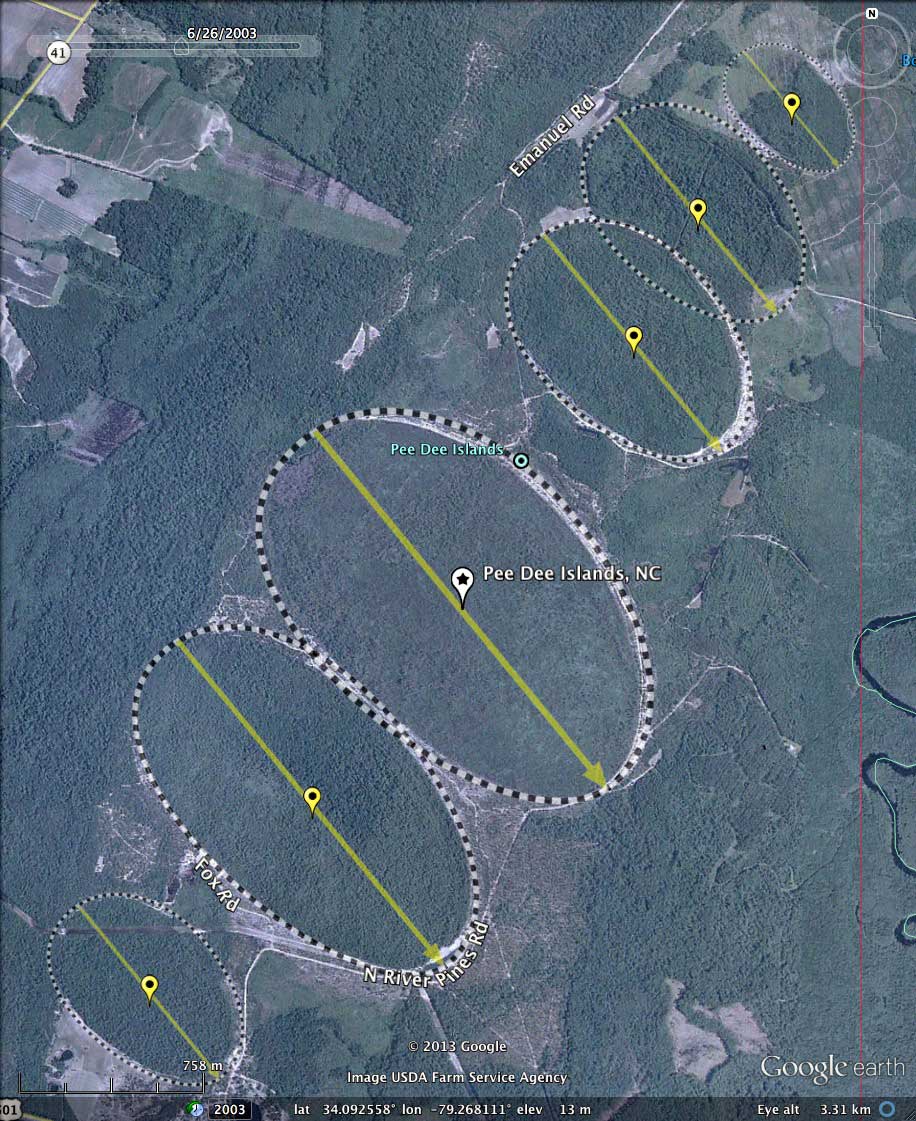
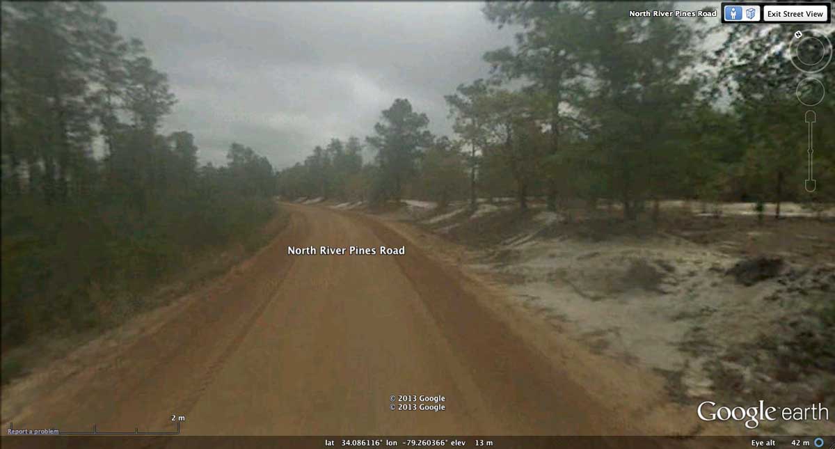
Google Streetview imagery is available along North River Pines Road, which loops along and around many of the individual bays of the Pee Dee Island cluster. A placemark in the attache KMZ file will take the viewer to an interesting location where it skirts around bay #136317_3607, passing just inside the rim. The raised relief of the white sandy rim can be seen clearly on one side of the road, while the bay proper drops off on the other side. You can also visit this imagery using Google Maps in your browser with this LINK.
In a scientific report by C. Wythe Cooke (1954), these shapes were judge to have been formed by eddies in the Pee Dee River estuary. A case was made for precessing eddies caused by the rotation of the Earth. Here are two excerpts from his REPORT:
"Probably all geologists who have investigated the Carolina bays would agree that they have passed through a stage as lake or pond, though the basins are now more or less boggy. Some bays still enclose bodies of open water. The differences of opinion about them relate chiefly to the origin of the lake basins and of the rims. Melton and Schriever (1933) and Prouty .(1952) attribute these features to a shower of meteorites, Johnson (1942) to upwelling artesian springs, and Grant (1945) to the hovering of fishes while spawning. In the present writer's opinion (Cooke, 1933, 1940, 1943, 1945a), nearly all the bays are original hollows in the surface of marine terraces ; and the sandy rims are bars, beaches, spits, and dunes built by currents, waves, and winds. The purpose of the present paper is to explain why these secondary features are elliptical
"The elliptical shapes of the bays are possibly caused by the gyroscopic effect of the rotation of the earth on a rotating body of water, an eddy."
At the time of Dr. Cooke's examinations of bays, it may not have been know that their locations extend westward to elevations above 200 meters - unlikely exposed as marine terraces for several millions of years.
Perhaps the name "Islands" was applied because each of these landforms presented a encapsulated habitat in the middle of the Pee Dee River floodplain, and are all situated on a contiguous strip of land which rises above the older flood plain to the west (at 11 meters AMSL) and the more recent floodplain to the east (at 10 meters AMSL).
Each of these bays is exquisitely crafted, and certainly worthy of their own "day"; but their years of being associated is worthy of acknowledgement.
Google Streetview imagery is available along North River Pines Road, which loops along and around many of the individual bays of the Pee Dee Island cluster. A placemark in the attache KMZ file will take the viewer to an interesting location where it skirts around bay #136317_3607, passing just inside the rim. The raised relief of the white sandy rim can be seen clearly on one side of the road, while the bay proper drops off on the other side. You can also visit this imagery using Google Maps in your browser with this LINK.
In a scientific report by C. Wythe Cooke (1954), these shapes were judge to have been formed by eddies in the Pee Dee River estuary. A case was made for precessing eddies caused by the rotation of the Earth. Here are two excerpts from his REPORT:
"Probably all geologists who have investigated the Carolina bays would agree that they have passed through a stage as lake or pond, though the basins are now more or less boggy. Some bays still enclose bodies of open water. The differences of opinion about them relate chiefly to the origin of the lake basins and of the rims. Melton and Schriever (1933) and Prouty .(1952) attribute these features to a shower of meteorites, Johnson (1942) to upwelling artesian springs, and Grant (1945) to the hovering of fishes while spawning. In the present writer's opinion (Cooke, 1933, 1940, 1943, 1945a), nearly all the bays are original hollows in the surface of marine terraces ; and the sandy rims are bars, beaches, spits, and dunes built by currents, waves, and winds. The purpose of the present paper is to explain why these secondary features are elliptical
"The elliptical shapes of the bays are possibly caused by the gyroscopic effect of the rotation of the earth on a rotating body of water, an eddy."
At the time of Dr. Cooke's examinations of bays, it may not have been know that their locations extend westward to elevations above 200 meters - unlikely exposed as marine terraces for several millions of years.
- Index #: 136317_3607
- Location: 34.09144709360101,-79.26790536491373
- Major: 1.93 km . . . Minor: 1.21 km
- Eccentricity: 0.775
- Area: 185.23 hectares
- Bearing: 140.69º
- Elevation: 13.02 m
- Archetype: bayCarolina
- Effective Diameter: 1,535.714 m
- Index #: 136317_3309
- Location: 34.08425501889714,-79.27463040353162
- Major: 1.76 km . . . Minor: 0.97 km
- Eccentricity: 0.832
- Area: 135.55 hectares
- Bearing: 140.69º
- Elevation: 12.03 m
- Archetype: bayCarolina
- Effective Diameter: 1,313.725 m
- Index #: 136317_4004
- Location: 34.10133169187163,-79.26024824394699
- Major: 1.18 km . . . Minor: 0.78 km
- Eccentricity: 0.746
- Area: 73.14 hectares
- Bearing: 140.69º
- Elevation: 11.94 m
- Archetype: bayCarolina
- Effective Diameter: 965.01 m
- Index #: 136317_4202
- Location: 34.106066032982135,-79.2573649268883
- Major: 1.06 km . . . Minor: 0.72 km
- Eccentricity: 0.725
- Area: 60.81 hectares
- Bearing: 140.69º
- Elevation: 11.17 m
- Archetype: bayCarolina
- Effective Diameter: 879.918 m
- Index #: 136317_3012
- Location: 34.07727244189003,-79.28192402175183
- Major: 0.93 km . . . Minor: 0.62 km
- Eccentricity: 0.744
- Area: 46.04 hectares
- Bearing: 140.69º
- Elevation: 11.87 m
- Archetype: bayCarolina
- Effective Diameter: 765.636 m
- Index #: 136317_4301
- Location: 34.109990136729095,-79.25316256830673
- Major: 0.62 km . . . Minor: 0.41 km
- Eccentricity: 0.748
- Area: 20.67 hectares
- Bearing: 140.69º
- Elevation: 11.18 m
- Archetype: bayCarolina
- Effective Diameter: 513.009 m
Copyright 2018 by Michael Davias