Dingle Pond, SC
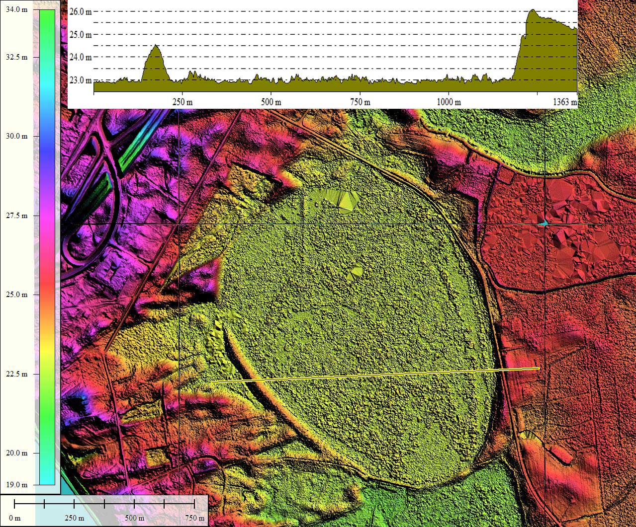
Here is a bay whose rim conforms tightly to the _*baySouth*_ archetype shape. The orientation is similar to other bays in the area.
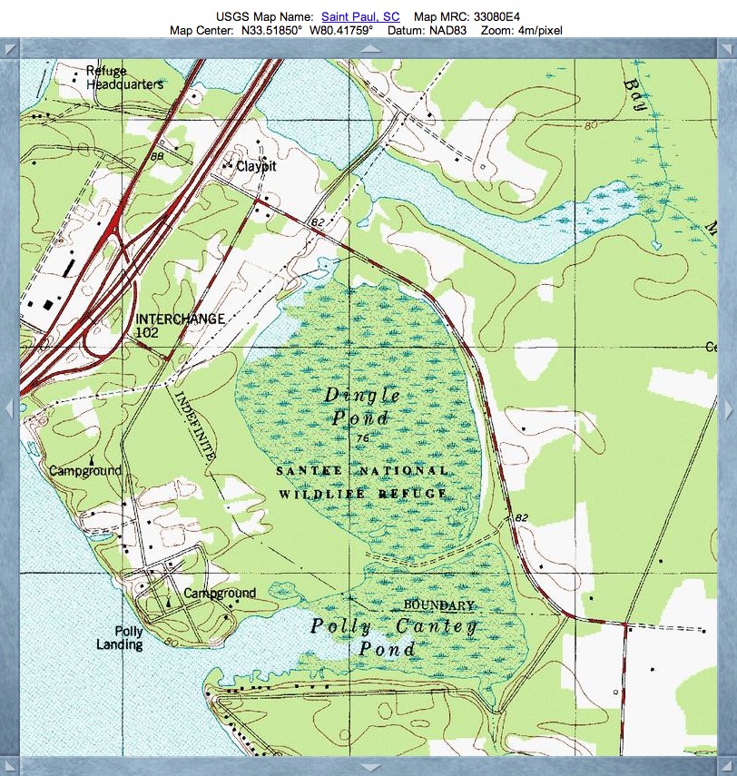
Dingle Pond is located within an expansive dune field along the eastern bank of the Santee River Basin and the Lake Marion reservoir. The bay and immediate area has been preserved as the Santee National Wildlife Refuge, which contains four parcels, scattered along the north shore of Lake Marion on both sides of I-95. The Dingle Pond Unit is open all year.
SCGreatOutdoors.com provides a description of the Refuge, found on their web page HERE.
Dingle Pond is a not a man-made pond as you might expect. It is a Carolina Bay whose origin is a mystery. This is the smallest unit of the Santee National Wildlife Refuge. A short hiking trail runs beside this pond, with a raised platform next to it which provides some wonderful views.
A photo album is available which shows views from inside the bay:
The U.S. Fish and Wildlife Service produced a brochure in 2010 on the Refuge that I have archived for downloading at
[LINK], which provides this description:
"The Dingle Pond Unit includes a large Carolina Bay, a naturally occurring depressional wetland, and provides habitat for wetland species including alligators, wood ducks, mallards, great blue herons, and other wildlife. The bay harbors a great diversity of songbirds as well as numerous reptile and amphibian species. Visitors may utilize a one-mile trail to get a closer look at wildlife on this unit. An observation tower is located on the edge of Dingle Pond and gives visitors a wonderful vantage point of this unique area."
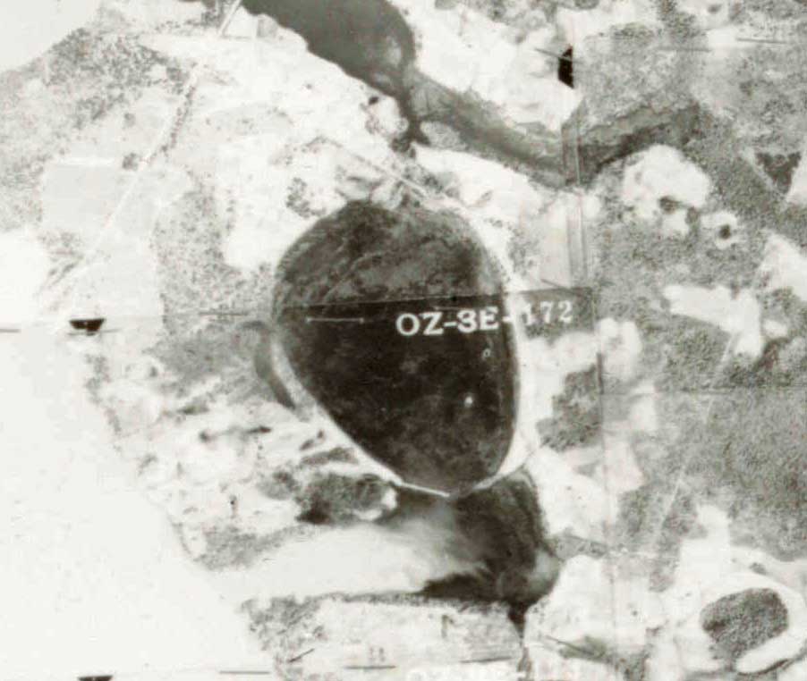
The LiDAR point clouds used were sourced from NOAA, were used to create the the hsv-shaded elevation maps for Dingle Pond. They contain 25cm gridded data, although the map tiles used in the referenced KMZ file were generated with a 1-meter grid to conserve bandwidth.
Google Streetview imagery is available along State Road 14-400 as it curves along the eastern rim of the bay for over a kilometer. The view from the rim down into the bay is hampered by the dense forest, but the drop-off from the road down into the water-filled bay is evident. Explore the Streetview interactively in your browser HERE.
The Carolina Bay Survey has identified and measured over 700 bays in Octant 134321, which puts the octant in the company of only a few with such a large concentration of bays. Their location and metrics can be referenced through a Fusion Table spatial visualization.
Index #: 134321_0766
Location: 33.51824275503035,-80.41687125867293
Major: 1.46 km . . . Minor: 1.09 km
Eccentricity: 0.66
Area: 126.46 hectares
Bearing: 143.81º
Elevation: 23.04 m
Archetype: baySouth
Effective Diameter: 1,268.911 m
Dingle Pond is located within an expansive dune field along the eastern bank of the Santee River Basin and the Lake Marion reservoir. The bay and immediate area has been preserved as the Santee National Wildlife Refuge, which contains four parcels, scattered along the north shore of Lake Marion on both sides of I-95. The Dingle Pond Unit is open all year.
SCGreatOutdoors.com provides a description of the Refuge, found on their web page HERE.
Dingle Pond is a not a man-made pond as you might expect. It is a Carolina Bay whose origin is a mystery. This is the smallest unit of the Santee National Wildlife Refuge. A short hiking trail runs beside this pond, with a raised platform next to it which provides some wonderful views.
A photo album is available which shows views from inside the bay:
The U.S. Fish and Wildlife Service produced a brochure in 2010 on the Refuge that I have archived for downloading at
[LINK], which provides this description:
"The Dingle Pond Unit includes a large Carolina Bay, a naturally occurring depressional wetland, and provides habitat for wetland species including alligators, wood ducks, mallards, great blue herons, and other wildlife. The bay harbors a great diversity of songbirds as well as numerous reptile and amphibian species. Visitors may utilize a one-mile trail to get a closer look at wildlife on this unit. An observation tower is located on the edge of Dingle Pond and gives visitors a wonderful vantage point of this unique area."
The LiDAR point clouds used were sourced from NOAA, were used to create the the hsv-shaded elevation maps for Dingle Pond. They contain 25cm gridded data, although the map tiles used in the referenced KMZ file were generated with a 1-meter grid to conserve bandwidth.
Google Streetview imagery is available along State Road 14-400 as it curves along the eastern rim of the bay for over a kilometer. The view from the rim down into the bay is hampered by the dense forest, but the drop-off from the road down into the water-filled bay is evident. Explore the Streetview interactively in your browser HERE.
The Carolina Bay Survey has identified and measured over 700 bays in Octant 134321, which puts the octant in the company of only a few with such a large concentration of bays. Their location and metrics can be referenced through a Fusion Table spatial visualization.
Index #: 134321_0766
Location: 33.51824275503035,-80.41687125867293
Major: 1.46 km . . . Minor: 1.09 km
Eccentricity: 0.66
Area: 126.46 hectares
Bearing: 143.81º
Elevation: 23.04 m
Archetype: baySouth
Effective Diameter: 1,268.911 m


Copyright 2018 by Michael Davias